SARAJEVO CITY MAP

|
|
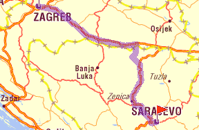
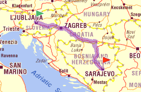
| LJUBLJANA(ZAGREB)-JAHORINA, VIA SLAVONSKI BROD, SARAJEVO, 580 km, including 300km highway. |
|
NOTE: Take the highway on M17 and folow the signs to Vogošća (Sarajevo suburban). Continue straight until you see the football stadium Koševo and the Olympic hall Zetra on your left. Continue straight and on the fifth traffic light turn left. River Miljacka should be on your right. Follow the tram and sfter six trafic lights contiune straight accross the tram rails. This is the road to Pale and Jahorina (Goražde). After this point road signs will take you to Jahorina. |
|
|
|
| ZAGREB - JAHORINA, VIA SLAVONSKI BROD, SARAJEVO 441km, including 150km highway. |
|
NOTE: Take the highway on M17 and folow the signs to Vogošća (Sarajevo suburban). Continue straight until you see the football stadium Koševo and the Olympic hall Zetra on your left. Continue straight and on the fifth traffic light turn left. River Miljacka should be on your right. Follow the tram and sfter six trafic lights contiune straight accross the tram rails. This is the road to Pale and Jahorina (Goražde). After this point road signs will take you to Jahorina. |
|
|
|
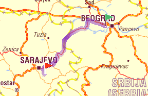
BEOGRAD-JAHORINA, shortest way VIA SABAC, ZVORNIK 311km |
|
| |
|
|
|
|